When I started mapping the then newly established backcountry campsites in the Black Forest back in 2017, I discovered, that the current mapping quality of campgrounds in Openstreetmap is actually quite poor. Unfortunately this situation did not improve that much since then.
Being active in OSM for more than 10 years now, I also know that improvements will only happen, when there is an appropriate special interest map which will help motivate people to improve tagging.
So here comes Open Camping Map!
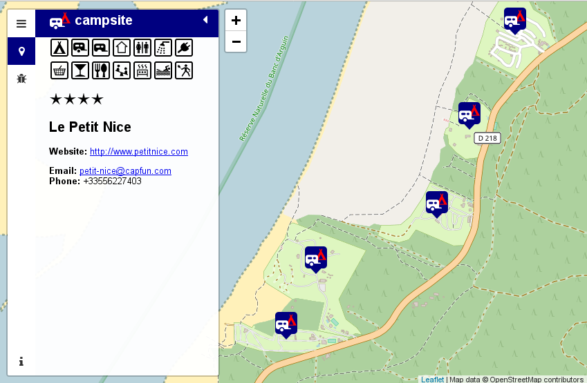
It is provided in the hope, that it will help getting mappers to improve the tagging. There is a bugs section and an edit button besides the actual info about a particular site. The Map will likely be of interest also to camping enthusiasts just looking for a site in a particular area.
Some statistics about the current (bad) state of campsites in Openstreetmap. There are about 120000 camping and caravan sites in our database. About 35000 of them do not even have a name tag. Another 39000 of them do only have a name tag and nothing else. Thus about half of the campsite data in Openstreetmap is of no further value than drawing a (sometimes named) tent on a rendered map.
Wouldn’t it be nice to use Openstreetmap to locate a suitable campsite for your next bicycle or hiking trip or just for your ordinary summer camping holiday?
I do think so, thus lets start and improve the map.
This task is even suitable for armchair mappers as most of the campsites do have a website nowadays. Probably I should also think about adding this to StreetComplete or MapRoulette challenge.
Finally here are some issues I came about while coding this map:
- Duplicating campsites as node and way ist not a good idea. Please map the area only.
- Please add at least some contact data to make the data useful for potential customers of a site.
- caravan only pitches inside a campsite should not to be tagged as caravan_site.
camp_site=camp_pitchwould be a better option. - I invented a tag called
permanent_camping=yes,no,onlyas it is common on many sites in Germany, that people rent a pitch on a seasonal basis and do not move their caravan for years. There are even sites where this is the only option.
So where will I go from here. I intend to make the map multilingual and probably add more improvement on the next Karlsruhe Hack Weekend. I will be happy about further suggestions for improvements or (even better) patches.
The backend is based on PostGIS and Imposm and the associated configuration is also available at GitHub. It is likely suitable for other POI maps. Thus feel free to contact me if you like to build one! The most easy frontend for such a map will likely be uMap.
Happy campsite mapping!
The schema for detail tagging of camp pitches within a campground/campsite is not firmly settled. Can you elaborate what tagging you will support.
https://wiki.openstreetmap.org/wiki/Proposed_features/Extend_camp_site#Tagging_of_individual_pitches
https://wiki.openstreetmap.org/wiki/Proposed_features/camp_site_pitch
Currently none of them.
I just wanted to clarify that I consider mapping a caravan_site inside a camp_site a bad thing to do.
Frankly, I never quite got the difference with caravan_site and camp_site. For me caravan_site equals camp_site+tents=no and this is exactly how it is currently represented on my map.
So where do you track the progress and the development? Is this happening on the GitHub repository: https://github.com/giggls/osmpoidb
osmpoidb is the backend code. Frontent code is at https://github.com/giggls/opencampsitemap
This is terrific. Really good to see this.
Thank you.
There are quite a few edits to be made – lots that I can see cannot have a caravan – no road access.
– off comments page please —
In a dry land the availability of water is a feature that should be tagged, drinking or not.
Hallo Sven,
gute Sache!
Die Unterscheidung zwischen camp_site und caravan_site halte ich schon für gerechtfertigt. Einzig die Bezeichnung caravan_site finde ich sehr unglücklich. Meist handelt es sich dabei um Wohnmobilstellplätze. Das kann im Extremfall einfach ein Parkplatz am Straßenrand sein mit Erlaubnis zum Übernachten. Man muss sich nicht anmelden und kann jederzeit kommen und gehen. Einen Namen hat sowas natürlich auch nicht. Deshalb würde mir auch das Wohnmobilpiktogramm dafür besser gefallen als das derzeitige Wohnwagenpiktogramm. Ein Wohnmobilabstellplatz ist für mich ein Platz, wo man sein Mobil im Winter unterstellen kann, wenn man es nicht braucht und es abgemeldet ist.
Für eine camp_site braucht man eigentlich immer sanitäre Einrichtungen und damit ein größeres behördliches Brimborium zur Genehmigung und Aufwand zum Unterhalt, so dass es davon viel weniger gibt. tents=no erweckt in mir die Vorstellung, man müsse draussen schlafen.
In vielen Fällen braucht man sowohl den Punkt für die Navigation zur Anfahrt, als auch die Fläche für das Erforschen vor Ort.
@wolfgang16: Darin was caravan_site sein soll unterscheiden sich die Einträge im deutschen und englischen Wiki. Ich mag das nicht bewerten, aber die Einstufung von caravan_site als Wohnmobilabstellplatz scheint ein rein deutsches Ding zu sein.
If you want to discuss issues please use OSM Forum or github issues for feature requests.
Sven
Hi Sven Gegus,
Would not it be better to make the first icon with a white tent and a red caravan, instead of a white caravan & a red tent ?
It seems logical since a campsite is originally a tentsite, even some sites dont accept trailers as you stated by naming caravan site.
As a randonneur I ll sleep on most of the campsites, I need 2×2 for one night, thank you, just asking.
Sven: ich seh da keinen grundlegenden Unterschied zwischen deutschem und englischem Wiki, ausser dass vielleicht in Deutschland (Europa?) alles etwas kleiner ist und deshalb lange Wohnwagengespanne gar nicht auf die Plätze passen. Die Kriterien im englischen Wiki sind:
– The arrival or departure may at any time, even at night, take place.
– There is no reception, where you would have to log on or off.
– The construction of tents, awnings is usually not allowed.
– The stay is limited to a few nights, seasonal or permanent camping is not permitted.
– Lower rates, perhaps free.
und das sind exakt die eines Wohnmobilstellplatzes.
@wolfgang16: https://github.com/giggls/opencampsitemap/commit/f412610cee2b864f87b36322b182ed6f3613a4c9
Hej,
Interessant finde ich ja immer noch, ob die hergrichteten Übernachtungsplätze an Wanderwegen und Kanurouten – die in Skandinavien ja absolut üblich sind – nicht kompatibler gemacht werden können. Im Moment wird meistens einfach die Infrastruktur (lean_to, fireplace, toilet) gemappt…
Ich meine diese Diskussion hatten wir schon mal. Ich sehe solche Plätze als backcountry. Spezialbedingungen kann man ja immer in description rein tun. Wie zum Beispiel hier:
https://www.openstreetmap.org/node/3064201499
P.S.: Diskussionen bitte im entsprechenden Forumsthread